| |
|
|
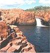
Situated 24 km off the Stuart Highway just out of Pine Creek
Northern Territory
it is a great little place to get your experience up in a
"Gorge" bushwalk, with shade & water and great rock formations
this is a must do.
|
 |
|
Situated 135 km west of Katherine Northern Territory along the Victoria Highway
the spring fed Flora river is a mass of water falls flowing over
naturally created tufa dams. The Flora flows to the Katherine/Daly/Flora
river junction and continues on as the Daly River. Great
campsite.
|
 |
|
The spot where all the Barramundi congregate is Beswick Falls
near Beswick Aboriginal Community Northern Territory. Also see a few highlights of
the Waterhouse River.
|
 |
|
If you really want to get away from it all and experience
rarely seen Northern Territory waterfalls, swamplands, arid land, bushland,
tropical rainforest pockets, Aboriginal rock art and spring
water, you gotta walk this track over 4-5 days.
|
 |
|
Lots of people go to the Mataranka Hot Springs at the
southern end of Mataranka, but recently a new hot springs has
opened up to the public, and here you may get some solitude and
stretch out with a few laps in the crystal clear spring water.
|
 |
|
Grove Hill Historic
Hotel Need to wet the whistle and see a remote but easily
accessible piece of the Northern Territory history. Just 16 km off the
Stuart Highway halfway between Darwin & Katherine.
|
 |
|
Douglas Hot Springs / Douglas Daly Tourist Park Try not to
confuse the two, situated about 12 km apart the Douglas Hot
Springs has a basic bush camp, where the Douglas Daly Tourist
Park (DDTP) has a great caravan/camping/cabin/bar environment
with its own unique natural tourist attractions. |

|
|
Cutta Cutta
Caves
30 Km South of Katherine, you can visit these
caves as you arrive in Katherine and start your Katherine Region
adventure. These cave are Tropical caves, with snakes & bats to
view. |

|
|
Edith Falls
62 Km north of Katherine (42 km up the Stuart
Highway & 20 km in)
Many walking trails and several waterfalls along
the Edith River.
Great camping sites with nice amenities & Kiosk. |

|
|
Nathan
River Road (Roper Highway Mataranka to Borroloola)
Looking for a slight detour off the bitumen for
the day or at your leisure with an overnight camp at a river
crossing? Then take the back road to/from Borroloola when doing
the trek across the Top End. |
 |

